The Industrial archaeology of Cwm Twrch by Dilys
Powell
The Railway
The Twrch is a tributary of the Tawe [Swansea] River and
lies on the border between the Brecon Beacons and the 'Valleys' [industrial
South Wales]. The Twrch and Hydfer Valleys
are the natural
route between Gurnos & Stennybridge
and more widely between
Swansea & Beacon. The route is used by the imaginary
Great Western Vale of Twrch Line. The
Twrch Valley has an interesting industrial history.
Introduction
Part 1: Historical
Limestone quarrying
In south Wales, lime was originally used for agricultural
purposes (Moore-Colyer, this volume, Chapter 5). In Cwm Twrch, farmers collected
lime after the harvest. They would take their donkeys or ponies to outcropping
coal seams on the valley sides of the Lower Twrch, then carry the coal across
the moorland to Blaen Llynfell, where it was used to burn limestone which
outcrops there. This was then brought down in panniers and spread onto the
enclosed land (Owen et al 1935, 18). By the nineteenth century, improved farming
methods had increased the demand for lime which resulted in building small stone
kilns which are now commonly found in areas close to limestone outcrops. The
main lime burning centres, such as Llandybie, were generally easily accessible
and supplied lime to a wide area. The Henllys site in Cwm Twrch, with its bank
of five kilns, is unusual in that it is relatively remote and inaccessible from
the agriculturally dominated areas of rural Carmarthenshire. The development of
lime burning on such a large scale at Henllys is the result of an expanding iron
industry along the northern rim of the coalfield during the nineteenth century.
Limestone from Henllys was also taken to the ironworks at Ynyscedwyn where it
was used as a flux in the furnaces. Limestone quarries were opened on the Black
Mountains in 1883 at Blaen Llynfell by John Hay, then the overseer at the
Cwmllynfell works. Scores of workmen lived in tents near the quarry during the
week, returning home down the valley at weekends. Quarrying was restricted to
the summer months, as the men were unable to endure the harsh conditions during
the bleak winter months (Owen 1912).
Lime was originally carried down to
the kilns on horses with panniers. In 1884, an incline was constructed by John
Hay for the kilns below Gelliau Farm to the mountain ridge. A steam engine at
the top of the incline lowered the full trucks and pulled up the empty ones.
From the top of the incline, a tramline still contours the hillside to the Blaen
Llynfell quarries along which the wagons would have been pulled by horses
(Owen1912; Owen et al, 1935).
Silica sand workings
Rottenstone and silica sand occur as a result of faulting to
the east of the limestone outcrop. This was in great demand at the Landore
(Glandwr) works, where it was used for polishing metals (Owen 1912). Later, a
silica brickworks was established at Brynhenllys, owned by the Tir Bach
Brickworks Company, Ystalyfera (Owen 1912). Before the tramroad was built, men
and girls would collect the soft sandstones in baskets from near Ffrydiau Twrch.
These were carried on horseback, the gatherers being paid one shilling per
journey, three times a day. After 1884, the silica sand was carried down on the
incline to the limekilns, and then on the tramroad to the brickworks at
Brynhenllys (Owen 1912).
Coal mining
As was the case with limestone
quarrying, coal mining began on a small scale, dictated by local needs. It was
used for lime burning and as a domestic fuel. It was relatively easy to extract
small amounts of coal from the seams outcropping on the valley sides using a
method known as 'patchio' (Owen 1912). Mining in its strictest sense did not
begin until the late eighteenth century, when a number of local businessmen
started to investigate the outcrops and drive levels
into the hillside along the line of the two to three underlying seams. The first
pit in the area was sunk by Christopher James and R C Aubrey at Cwmllynfell.
Here the coal was raised by a water balance system which overbalanced an empty
cage at the top while drawing a full cage to the surface (Owen et al 1935). As
the Llynfell did not contain sufficient water to operate the balance system
during the summer months, a channel known as 'feeder Jams’ was constructed to
carry water from the Twrch near Ffrydiau (Thomas 1970, 72). However, mining
remained small-scale until 1838. Before that time it had not been possible to
use anthracite in the iron industry, but in 1838, George Craneand David Thomas
of the Ynyscedwyn works adapted the hot blast process, enabling anthracite to be
used in the blast furnace. This greatly increased the local demand for coal and
led to an expansion in both the number and scale of the collieries in the
valley.
Brynhenllys
Brynhenllys Colliery was opened in 1792 under the management
of five local Welsh businessmen: Enoch Owen Powell, Thomas Powell, Richard
Lewis, his son Hywel Lewis and Levi Rees (Thomas 1970, 72; Anon 1901). Locally
it was known as Gwaith y Powelliaid. In its heyday 300 workers were employed
there extracting 120 tons a day (Evans 1820). After the closure of the
Ynyscedwyn Iron Works in 1877 the coal was mainly exported through the port of
Swansea.
Operations at Lower Brynhenllys Colliery (SN756 123) were
powered by three waterwheels, turned by water from leats. The uppermost feeder
was tapped from just below the weir, opposite Upper Brynhenllys Colliery. By
taking the water supply from higher up the valley, a fall of 10-20 feet (3-6 m)
could be obtained, giving sufficient power to rotate the large wooden
waterwheels. These in turn operated the winding engine, screening machinery and
the beam pump which drained the mine (Thomas 1970, 75).Nothing remains of either
the waterwheels or their associated machinery. The leat can, however, be traced
from the weir, following a course roughly parallel to the tramroad. This feeder
also turned the wheel which operated the machinery at the silica brickworks.
These were situated just above Lower Brynhenllys Colliery, to the south of the
present road bridge.
Upper Brynhenllys
Henllys
Originally, coal at Henllys was extracted almost exclusively
for use in the limekilns under the auspices of the Black Mountain Silica Sand,
Lime, Brick and Colliery Co Ltd, owned by John Hay. However, production of lime
ceased in the late 1880s, as a result of the migration of the iron industry
towards the coast, since local iron ore resources had been exhausted and the
industry became dependent on imported supplies. After a period of inactivity,
the concern was sold in 1898 to the Black Mountain Anthracite Co, which opened
Henllys Vale Colliery, near the end of John Hay's incline. Unlike earlier pits,
power to haul coal to the surface was provided by a coal-fired steam engine. The
engine house chimney still stands. It seems likely that at least in the initial
stages of development water power was used to drive coal-sorting screens. There
then followed a period of prosperity, the work force rising to 141 in 1904.
However, the profitability of the company soon declined so rapidly that it was
offered for auction in 1906. The sale included the colliery, silica and
limestone quarries, mineral rights over 492.5 acres (c 200 ha), buildings, fixed
and loose plant, machinery, railway sidings, stocks, stores and effects. Bids
did not reach a realistic level, and the concern was withdrawn from the auction
at £ 5,500. The colliery lay idle for a while, then was restarted by a new
company, the New Henllys Anthracite Co Ltd, to be worked until the First World
War, which effectively withdrew the labour force, and forced the mine to remain
idle for the duration of hostilities. In the event, it proved impractical to
recommence operations after the War and the mine was finally abandoned in 1918.
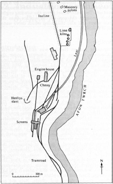
Figure 24 Henllys Colliery 1905: leats and tramroads of Lower
Cwm Twrch (from OS 25-inch plan)
Part 2: Industrial archaeology: a survey of existing
structures at Cwm Twrch (Fig 24)
Henllys
The best preserved relics are found at Henllys.
Limekilns
(SN 7627 1378). Limekilns are arguably the most important
feature of the site, being unique in their state of preservation and their
remote location, away from major transport routes. It consists of five enormous
rubble-choked kilns which are structurally sound. The bank of
kilns was built into a steep slope, probably
partly artificial, for top-loading. The kilns appear to have been constructed in
two phases. The northern three kilns (one of which has been blocked off) have
tall, stone-faced arches, the passages having been extended by the addition of a
second facing wall. Their interior is also of stone. The later kilns are better
preserved and retain their inner brick walls and tapping arches. The circular
kilns have a brick lining above square bases.
Chimney (SN 7624
1378). The chimney is circular and of red brick, rising to some 30.5 m above its
octagonal base and capped by a now incomplete ornamental corbell. There is an
archway on the southern side of the base. Dart of which has now were demolished
sometime in the 1950s. The suggestion has been forwarded that it acted as a
ventilation shaft for underground workings, despite the conflicting evidence of
coal and ash found at the base. However, local people say that the chimney was
once attached to an engine house. Some sources suggest that this steam engine
worked the incline, but this is unlikely as the remains of an engine house and
small brick chimney are to be found at the top of the incline. Old maps (OS
25-inch 1905) show that the engine must have been used for hauling coal to the
surface from Henllys Slant. The impressive size of the chimney is the result of
its location within the confines of a narrow valley. It had to be constructed
sufficiently tall to allow the smoke to escape.
Masonry Pylons (SN
7623 1383). Beyond the kilns are the remains of three or four stone-built towers
which may have carried an aqueduct, As it is not possible to follow the line
taken by the associated leat, their purpose is not yet clear.
Henllys Slant (SN
7617 1364). The stone-lined entrance to Henllys Slant is still visible,
partially hidden by debris, which has fallen from above.
Screening wall (SN
7619 1361). The entrance to the colliery is dominated by a large flat area
surrounded by ‘the imposing screen wall. After being hauled up the slant by
steam engine, coal was taken to the top of the screen wall by truck and then
poured down the chute onto conveyor belts. After sorting, it was loaded into
trucks and taken down the valley on the tramline. The screens were operated by
water power, at least in the initial stages of development. Water was taken from
a weir at (SN 7632 1388), via a stone-lined leat, to a wheelpit at the eastern
end of the screening wall. A shallow depression marks the former channel, which
returned the water back to the river.
Brynhenllys
Little of interest is now visible at
Upper Brynhenllys. Even the course of the leat which fed the large wooden water
wheel is not readily discernible, being marked at best by a line of iron pegs,
which once held the wooden trough in place. The most notable feature of the
valley below Henllys is the leat which was tapped just below the weir, I near
the remains of Upper Brynhenllys Colliery. It has a rough concrete retaining
wall, emphasising just how recently water had to be relied upon as a source of
power. The regulating weir lies a short distance downstream. From this water
level built up on the river it would overflow into! the leat, the course of
which can still be followed downstream for a considerable distance. The leat is
bridged about 300 m from its source by a masonry structure, vertical on its
upstream side, but with supporting buttresses on the downstream side. Between
each pair of buttresses is a wooden lintel, approximately one foot (0.3 m)
collapsed. the chimney lining has deteriorated and loose yellowish bricks lie
inside on a basal fill of coal, dust, and ash. The purpose of the chimney is not
clear from structural evidence as the surrounding buildings off the ground,
below which the water would have been channelled. Its function is not yet
clearly understood. Some 50 m north of the road-bridge, the route of the leat
becomes indistinct. Originally, the water split into two channels here. One
branch was conduited under the tramline and then followed it down to Lower
Brynhenllys Colliery; the other was taken by aqueduct some 20 m to the
brickworks. Any remains of the aqueduct system still surviving in situ, will now
be buried below the spoil.
Brynhenllys Tramroad
In addition to the tramroad built to carry silica sand down
from the Black Mountain quarries to the brickworks, a second tramroad was built
at a higher level, to transport coal from Upper Brynhenllys Colliery. Although
the two tramroads are parallel for much of their course to the county road from
Upper Brynhenllys, the gradient on the upper tramroad is less. In places the
side of the higher track is held in place by railway sleepers and iron stakes,
but elsewhere the height differential is so great that a retaining wall had to
be built. Within the wall is an interesting feature which has proved to be
totally inexplicable. An oven-like structure, some 0.75 m wide going back about
2 m, has been built into the retaining wall. The sides and roof are well
constructed in stone but there is no back as such, the tramline infill being
visible. There are small openings on either side which appear to have no
connection to the central cavity.
Conclusion
industrial landscape through routine historical research.
Furthermore, systematic attempts to correlate fieldwork observations with both
manuscript and published sources have resulted in clear explanations of the
functions of otherwise potentially inexplicable features on the ground, giving
some idea of the area's economic activity in its heyday. Today the landscape of
Cwm Torch is under great pressure from proposals to work opencast coal seams.
Although the intended area of opencasting lies to the east of most features
described here, this investigation illustrates that a valley such as this, still
endowed with recognisable abandoned plant, could be extremely vulnerable to
future economic activity. Should further applications for open cast development
be forthcoming in Cwm Twrch, this historically interesting industrial landscape,
currently unprotected by Statute, will require careful monitoring if the
industrial community of south Wales is not to lose further important heritage
sites.
Bibliography
Evans, W J, 1890, Hanes Cwmtwrch a
Cwm-Uynfell, Cwmtwrch
Owen, J, 1912 Cyflwynedig i
Gystadleuaeth,unpubl MS, May 18th 1912
Owen, J Dyfnallt, Jones, J D, and
Davies, W D, 1935 Hanes Eglwys Cwmllynfell
Thomas, W G, 1970 'A study of some remains of past mining
activity in the Upper Tawe Valleys',
Brycheiniog, 14,
67–78 HMSO, 1930 Catalogue of
plans of abandoned mines, Vol 4, London: HMSO
It has been found possible to greatly enhance the outcome of
a local area study of a neglected derelict